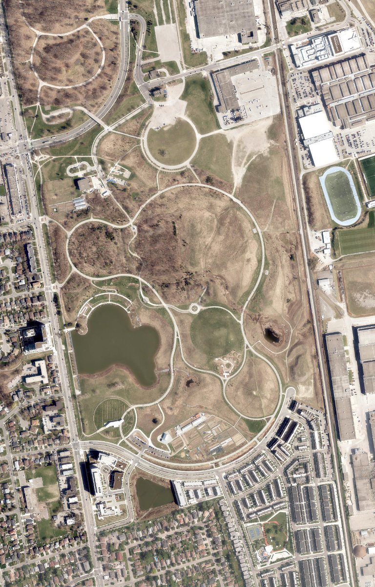
Downsview Park
Waterfront Park, below average overall (score 30, rank ~29th percentile). Strongest: enclosure; weakest: edge activation.
Aerial, City of Toronto orthophoto, ~8 cm/px source · cached 5/9/2026
Downsview Park scores 29.7 / 100. Strongest dimensions: enclosure / eyes on park and connectivity. Weakest: amenity diversity (0). Border-vacuum risk is elevated (100). This score is a transparent reading of Jane Jacobs-style vitality factors, not a definitive judgment.
Area · 78.60 ha
Weighted across six dimensions · confidence 63%
Scores are not bell-curved. Percentiles and expected scores provide context without changing the underlying model.
Loading map…
The parks map is loading.Explain this score
Where did the 30 come from? Each weighted contribution against a neutral 50 baseline. Green = pushed up; red = pulled down.
Sum of contributions = the headline score. A negative bar means that dimension dragged the park below the city-wide neutral baseline.
Why this park works
Downsview Park works because its enclosure score (92) is one of the city's strongest and its connectivity (77) is also top decile (503 mid-rise buildings frame the edge with passive surveillance).
What limits this park
Downsview Park is held back by edge activation (0, bottom quartile): the surrounding streets carry too few active uses to spill into the park; border-vacuum risk is also elevated (100).
Most distinctive characteristic
Most distinctive feature: exceptionally high enclosure (92, top decile).
Jacobs reading
Downsview Park sits between an urban social park and an ecological retreat: moderately useful for both, exceptionally suited to neither.
Tradeoffs
- Connectivity (77) significantly outpaces natural comfort (33): well placed in the city but offers little shade or ecological respite.
- The park is enclosed by buildings (92) but the surrounding streets are quiet (edge activation 0): frame without animation.
- 6 nearby towers cast wind and shadow without contributing canopy: passive surveillance is plentiful but human-scale comfort is not.
- High connectivity coexists with high border-vacuum risk (100): much of that connectivity is to highways, rail, or parking lots, not to neighbourhoods.
Typology classification
Classified as Waterfront Park: 5% water surface inside park
Edge Activation
Within 100 m of the park edge: 33 active uses (transit_stop, retail, restaurant, cafe) and 19 dead/hostile uses (parking_lot, rail). Active edges keep "eyes on the park" through the day; parking lots, blank institutional walls, rail and highway frontages drain street life.
Source: OSM POIs (amenity/shop) + Toronto Building Footprints + land use
Connectivity
Connectivity blends paths, intersections, transit, entrances, and edge density. This park has 205 mapped paths/walkways and 138 sidewalk segments within 50 m; 15 street intersections within 100 m; 30 transit stops within a 400 m walk; 38 estimated access points across ~5,620 m of perimeter. low edge density, significant superblock penalty applied. Source coverage: centreline, pedestrian_network, transit_osm.
Source: Toronto Centreline V2 + Pedestrian Network + OSM transit stops
Amenity Diversity
No amenities recorded. Score is 0 until inventory is loaded.
Source: Toronto Parks & Recreation Facilities + OSM amenity tags
Natural Comfort
Natural-comfort components for this park: 0.2% estimated tree canopy; 5.1% water surface; 20 city-mapped trees inside the polygon (0.3/ha). Reading: water-cooled. Source coverage: treed_area, waterbodies, street_trees. Impervious surface is approximated (Toronto's authoritative layer ships only as a raster GeoTIFF).
Source: Toronto Treed Area + Ravine + Waterbodies + Street Tree Inventory
Enclosure / Eyes on Park
703 buildings within 25 m of the park edge (503 mid-rise, 194 low-rise, 6 tower); avg edge height 11.1 m (~4 floors); 12.5 buildings per 100 m of 5,620 m perimeter (strong frontage density); edges are at a Jacobs-scale walkable mid-rise (3 to 7 floors); 6 towers ≥ 40 m within 25 m of the edge. "Eyes on the park" come strongest from the 503 mid-rise edge buildings.
Source: Toronto 3D Massing (building footprints + heights)
Border Vacuum Risk
Border-vacuum factors within 50 m of the park: parking_lot, parking_lot, parking_lot, parking_lot, parking_lot, parking_lot, Newmarket Subdivision, DriveTest parking, DriveTest Staff Parking Only, Visitors Parking, parking_lot. Jacobs warned that highways, rail, parking lots and blank institutional edges act as "vacuums" that suppress foot traffic and isolate the park from its neighbourhood.
Source: Toronto Street Centreline (highways) + rail layer + OSM landuse + building footprints
Equity Context
Equity Context requires inputs not yet loaded for this park (Toronto Neighbourhood Profiles). Score is held at a neutral 50 with low confidence. Read with caution.
Source: Toronto Neighbourhood Profiles
Amenities (0)
No amenities recorded for this park.
Nearby active-edge features (75)
- parking lot0 m
- parking lot0 m
- parking lot0 m
- parking lot0 m
- parking lot0 m
- parking lot0 m
- transit stop: 35 Carl Hall Road0 m
- parking lot: DriveTest parking0 m
- parking lot: DriveTest Staff Parking Only0 m
- parking lot: Visitors Parking0 m
- transit stop: Downsview Park Boulevard at George Buchart Drive3 m
- transit stop: Sheppard Avenue West at Keele Street East Side4 m
- transit stop: Downsview Park Boulevard at Keele Street5 m
- transit stop: Wycombe Road10 m
- transit stop: Keele St at Diana Dr10 m
- transit stop: Opposite 35 Carl Hall Road10 m
- rail: Newmarket Subdivision12 m
- transit stop: Downsview Park Boulevard at Stanley Greene Boulevard22 m
- transit stop: Keele Street at Downsview Park Boulevard25 m
- transit stop: Keele Street at Denbigh Crescent South Side27 m
- transit stop: Keele Street at Diana Drive South Side30 m
- transit stop: Keele Street32 m
- transit stop: Keele Street at Sheppard Avenue West South Side32 m
- transit stop: Keele Street at Wycombe Road34 m
- transit stop: Stanley Greene Boulevard at Downsview Park Boulevard35 m
- transit stop: Keele Street at Whitburn Crescent37 m
- parking lot40 m
- transit stop: Keele Street41 m
- rail54 m
- parking lot56 m
- restaurant: Champion Döner60 m
- restaurant: Vaikha60 m
- restaurant: Pizza Hut60 m
- restaurant: Smoke 'n' Roti60 m
- retail: Excel Nails & Spa60 m
- retail: Coin Laundry60 m
- retail: HD Nails61 m
- restaurant: A&W61 m
- cafe: Tim Hortons61 m
- restaurant: Subway62 m
- restaurant: Church's Chicken62 m
- retail63 m
- restaurant: Ellias Restaurant & Bar63 m
- retail: BSW Beauty Supply64 m
- transit stop: Sheppard Avenue West66 m
- parking lot66 m
- parking lot68 m
- parking lot72 m
- parking lot80 m
- parking lot87 m
- retail91 m
- parking lot93 m
- transit stop: Carl Hall Road at Centennial College106 m
- parking lot109 m
- parking lot109 m
- parking lot110 m
- parking lot118 m
- retail: Ryna's Nail Keele Beauty and Spa126 m
- restaurant: Mumtaz Grill Restaurant154 m
- parking lot154 m
- parking lot157 m
- restaurant: Pizza Pizza161 m
- transit stop: Locust Lodge Gardens at Stanley Greene Boulevard161 m
- parking lot166 m
- parking lot172 m
- retail: Bob Variety Store172 m
- transit stop: Carl Hall Road at Centennial College178 m
- restaurant: Mang Tomas Lechon180 m
- parking lot183 m
- restaurant: Pho Huong Trang187 m
- parking lot188 m
- school: Africentric Alternative School188 m
- retail: AyaSofya Super Market192 m
- transit stop: Sheppard Avenue West at John Drury Drive197 m
- parking lot199 m
Park profile
Five-axis radar across the structural dimensions.
Citywide percentile ranks
Across all Toronto parks in the dataset.
- Overall vitality29th
- Edge activation15th
- Connectivity97th
- Amenity diversity22th
- Natural comfort17th
- Enclosure97th
Most similar parks
Closest in metric space across the five structural dimensions.
- Four Winds Allotment GardensNeighbourhood Park34
- Mccaul - Orde ParketteUrban Plaza34
- Gwendolyn Macewen ParketteUrban Plaza38
- West Toronto Rail PathCorridor / Linear Park31
- Broadview Subway Station ParketteUrban Plaza35
Most opposite parks
Furthest in metric space. Useful for recognising what kind of park this isn’t.
- Trca Lands ( 26)Ravine / Naturalized Park27
- Toronto Islands - Muggs Island ParkRavine / Naturalized Park25
- Rouge ParkRavine / Naturalized Park28
- Rouge ParkWaterfront Park25
- Rouge ParkRavine / Naturalized Park26
Human activity signals: not available
No activity signals have landed for this park yet. The model has scored its physical form but it can’t yet say how often it’s programmed, photographed, or walked through. See /data-ethics for what we will and will not collect.
Does this score feel accurate?
Your read of Downsview Parkmatters. We’re testing whether the model lines up with how people actually use the park. Submissions are stored locally; no account needed.
Tell us how this park feels
We measure structure (canopy, edges, connectivity). You measure feeling. Both matter, and disagreement is itself useful civic data.
What would improve this park?
Generated from the weakest measured dimensions: a starting point, not a prescription.
- Activate the edges: encourage cafés, retail or community uses on the streets that face the park; replace blank or parking-lot edges where possible.
- Diversify what people can do in the park (playground, washroom, water, shade, performance, sport, garden): even small additions raise this score.
- Increase canopy and reduce paved area. Shade and water features extend usable hours and seasons.
- Mitigate border vacuums (highways, rail, parking) with active programming on the still-permeable edges and treat the hostile edge as a design challenge.
Data sources
- City of Toronto Open Data: Parks (Green Space)Polygon boundaries, official names, types.
- Parks & Recreation FacilitiesInventory of in-park amenities (washrooms, fields, rinks…).
- Toronto Pedestrian NetworkSidewalk segments around and through parks; estimated park entrances.
- Toronto Centreline V2Street segments + intersection nodes near park edges; trails and walkways.
- Toronto 3D MassingBuilding footprints + heights for edge-building counts, frontage density, and tower-in-the-park risk.
- Toronto Treed AreaTree canopy share inside park polygons via stratified-grid sampling.
- Toronto Waterbodies & RiversWater surface inside parks + nearest-water distance for cooling.
- Ravine & Natural Feature ProtectionRavine overlap as a cooling / natural-comfort signal.
- Toronto Street Tree InventoryTree count + density inside park polygons.
- Neighbourhood Profiles(Pending) Equity context proxy.
- OpenStreetMap (Overpass API)Cafés, restaurants, retail, transit stops, parking, highways, rail.