West Toronto Rail Path
Corridor / Linear Park, middle of the pack overall (score 31, rank ~33th percentile). Strongest: connectivity; weakest: edge activation.
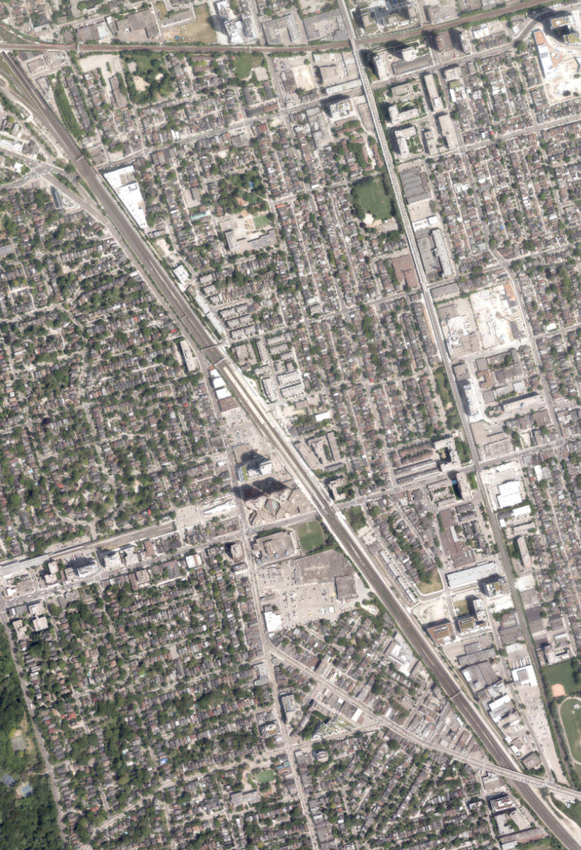
Aerial, City of Toronto orthophoto, ~8 cm/px source · cached 5/9/2026
West Toronto Rail Path scores 30.6 / 100. Strongest dimensions: enclosure / eyes on park and connectivity. Weakest: amenity diversity (0). Border-vacuum risk is elevated (100). This score is a transparent reading of Jane Jacobs-style vitality factors, not a definitive judgment.
Area · 2.37 ha
Weighted across six dimensions · confidence 63%
Scores are not bell-curved. Percentiles and expected scores provide context without changing the underlying model.
Loading map…
The parks map is loading.Explain this score
Where did the 31 come from? Each weighted contribution against a neutral 50 baseline. Green = pushed up; red = pulled down.
Sum of contributions = the headline score. A negative bar means that dimension dragged the park below the city-wide neutral baseline.
Why this park works
West Toronto Rail Path works because its connectivity score (81) is one of the city's strongest and its enclosure (84) is also top quartile (73 transit stops sit within a 400 m walk; 67 intersections fall within 100 m of the edge).
What limits this park
West Toronto Rail Path is held back by edge activation (0, below-average): the surrounding streets carry too few active uses to spill into the park; border-vacuum risk is also elevated (100).
Most distinctive characteristic
Most distinctive feature: exceptionally high connectivity (81, top decile).
Jacobs reading
West Toronto Rail Path sits between an urban social park and an ecological retreat: moderately useful for both, exceptionally suited to neither.
Tradeoffs
- Connectivity (81) significantly outpaces natural comfort (39): well placed in the city but offers little shade or ecological respite.
- The park is enclosed by buildings (84) but the surrounding streets are quiet (edge activation 0): frame without animation.
- 13 nearby towers cast wind and shadow without contributing canopy: passive surveillance is plentiful but human-scale comfort is not.
- High connectivity coexists with high border-vacuum risk (100): much of that connectivity is to highways, rail, or parking lots, not to neighbourhoods.
Performance in context
- Reads as a modest underperformer relative to comparable parks (gap -6; cohort: medium Corridor / Linear Park).
Typology classification
Classified as Corridor / Linear Park: shape elongation 7.9× a circle of equal area. Secondary read: Neighbourhood Park (2.4 ha, framed by 106 mid-rise vs 13 towers).
Edge Activation
Within 100 m of the park edge: 50 active uses (transit_stop, cafe, restaurant, retail, community) and 57 dead/hostile uses (rail, parking_lot, highway). Active edges keep "eyes on the park" through the day; parking lots, blank institutional walls, rail and highway frontages drain street life.
Source: OSM POIs (amenity/shop) + Toronto Building Footprints + land use
Connectivity
Connectivity blends paths, intersections, transit, entrances, and edge density. This park has 28 mapped paths/walkways and 74 sidewalk segments within 50 m; 67 street intersections within 100 m; 73 transit stops within a 400 m walk; 30 estimated access points across ~4,307 m of perimeter. low edge density, significant superblock penalty applied. Source coverage: centreline, pedestrian_network, transit_osm.
Source: Toronto Centreline V2 + Pedestrian Network + OSM transit stops
Amenity Diversity
No amenities recorded. Score is 0 until inventory is loaded.
Source: Toronto Parks & Recreation Facilities + OSM amenity tags
Natural Comfort
Natural-comfort components for this park: 3.7% estimated tree canopy; nearest waterbody ~977 m; 12 city-mapped trees inside the polygon (5.1/ha). Reading: exposed. Source coverage: treed_area, waterbodies, street_trees. Impervious surface is approximated (Toronto's authoritative layer ships only as a raster GeoTIFF).
Source: Toronto Treed Area + Ravine + Waterbodies + Street Tree Inventory
Enclosure / Eyes on Park
310 buildings within 25 m of the park edge (106 mid-rise, 191 low-rise, 13 tower); avg edge height 12.4 m (~4 floors); 7.2 buildings per 100 m of 4,307 m perimeter (strong frontage density); edges are at a Jacobs-scale walkable mid-rise (3 to 7 floors); 13 towers ≥ 40 m within 25 m of the edge. "Eyes on the park" come strongest from the 106 mid-rise edge buildings.
Source: Toronto 3D Massing (building footprints + heights)
Border Vacuum Risk
Border-vacuum factors within 50 m of the park: Weston Subdivision, Galt Subdivision, Galt Subdivision, Weston Subdivision, Weston Subdivision, Weston Subdivision, Weston Subdivision, Weston Subdivision, Galt Subdivision, Galt Subdivision, parking_lot, parking_lot, Weston Subdivision, Weston Subdivision, Weston Subdivision, Weston Subdivision, Galt Subdivision, Weston Subdivision, Weston Subdivision, Weston Subdivision, Galt Subdivision, Galt Subdivision, parking_lot, Galt Subdivision, parking_lot, Weston Subdivision, Weston Subdivision, Weston Subdivision, Weston Subdivision, Weston Subdivision, parking_lot, parking_lot, parking_lot, parking_lot, Galt Subdivision, Bloor Street West, Bloor Street West. Jacobs warned that highways, rail, parking lots and blank institutional edges act as "vacuums" that suppress foot traffic and isolate the park from its neighbourhood.
Source: Toronto Street Centreline (highways) + rail layer + OSM landuse + building footprints
Equity Context
Equity Context requires inputs not yet loaded for this park (Toronto Neighbourhood Profiles). Score is held at a neutral 50 with low confidence. Read with caution.
Source: Toronto Neighbourhood Profiles
Amenities (0)
No amenities recorded for this park.
Nearby active-edge features (80)
- rail: Weston Subdivision0 m
- rail: Galt Subdivision6 m
- rail: Weston Subdivision7 m
- rail: Weston Subdivision8 m
- rail: Weston Subdivision10 m
- retail: Rily Kitchen11 m
- retail: Petite Bouchée11 m
- retail: Ride Away Bikes11 m
- rail: Weston Subdivision11 m
- rail: Weston Subdivision11 m
- transit stop: Bloor12 m
- transit stop: Bloor12 m
- cafe: Gaspar Cafe12 m
- retail: Okayok12 m
- rail: Weston Subdivision13 m
- retail: June Blooms Holiday Market13 m
- rail: Weston Subdivision13 m
- retail: The Art Room14 m
- retail: Hair Collective14 m
- parking lot14 m
- retail: West End Tool Library15 m
- rail: Weston Subdivision15 m
- transit stop: Bloor15 m
- rail: Weston Subdivision15 m
- transit stop: Bloor16 m
- transit stop: Bloor16 m
- transit stop: Bloor16 m
- rail: Weston Subdivision16 m
- parking lot16 m
- rail: Weston Subdivision17 m
- community: George Chuvalo Neighbourhood Centre17 m
- parking lot17 m
- cafe: LOFT Kitchen Cafe18 m
- rail: Weston Subdivision19 m
- highway: Bloor Street West20 m
- rail: Weston Subdivision20 m
- retail: JR Auto Care20 m
- rail: Weston Subdivision23 m
- rail: Weston Subdivision24 m
- parking lot25 m
- rail: Galt Subdivision26 m
- highway: Bloor Street West26 m
- rail: Weston Subdivision27 m
- rail: Galt Subdivision28 m
- parking lot28 m
- transit stop: Bloor29 m
- transit stop: Bloor29 m
- rail: Weston Subdivision29 m
- parking lot29 m
- transit stop: Sterling Road30 m
- parking lot30 m
- rail: Galt Subdivision30 m
- rail: Galt Subdivision30 m
- rail: Galt Subdivision31 m
- rail: Galt Subdivision32 m
- rail: Galt Subdivision32 m
- rail: Galt Subdivision33 m
- parking lot40 m
- transit stop: Humberside Avenue43 m
- restaurant: Blondies Pizza45 m
- transit stop: Dupont St at Osler St47 m
- parking lot51 m
- parking lot52 m
- parking lot54 m
- transit stop: Glenlake Avenue55 m
- parking lot56 m
- transit stop: Jerome Street56 m
- transit stop: Humberside Avenue57 m
- transit stop: Dundas West61 m
- cafe: Saving Mondays62 m
- retail: Good Mood Hair Shop63 m
- parking lot63 m
- restaurant: Aisle 364 m
- retail: Besi Auto Collision Limited65 m
- transit stop: Sorauren Avenue65 m
- retail: 3 Jit Variety67 m
- transit stop: Glenlake Avenue67 m
- parking lot68 m
- transit stop: Sterling Road68 m
- rail: Weston Subdivision69 m
Park profile
Five-axis radar across the structural dimensions.
Citywide percentile ranks
Across all Toronto parks in the dataset.
- Overall vitality33th
- Edge activation34th
- Connectivity99th
- Amenity diversity41th
- Natural comfort35th
- Enclosure90th
Most similar parks
Closest in metric space across the five structural dimensions.
- Four Winds Allotment GardensNeighbourhood Park34
- Mckenzie ParketteUrban Plaza38
- Downsview ParkWaterfront Park30
- Queen'S ParkNeighbourhood Park33
- Beaver - Lightbourn ParketteUrban Plaza37
Most opposite parks
Furthest in metric space. Useful for recognising what kind of park this isn’t.
- Trca Lands ( 26)Ravine / Naturalized Park27
- Toronto Islands - Muggs Island ParkRavine / Naturalized Park25
- Rouge ParkRavine / Naturalized Park28
- Rouge ParkRavine / Naturalized Park26
- Rouge ParkWaterfront Park25
Human activity signals: not available
No activity signals have landed for this park yet. The model has scored its physical form but it can’t yet say how often it’s programmed, photographed, or walked through. See /data-ethics for what we will and will not collect.
Does this score feel accurate?
Your read of West Toronto Rail Pathmatters. We’re testing whether the model lines up with how people actually use the park. Submissions are stored locally; no account needed.
Tell us how this park feels
We measure structure (canopy, edges, connectivity). You measure feeling. Both matter, and disagreement is itself useful civic data.
What would improve this park?
Generated from the weakest measured dimensions: a starting point, not a prescription.
- Activate the edges: encourage cafés, retail or community uses on the streets that face the park; replace blank or parking-lot edges where possible.
- Diversify what people can do in the park (playground, washroom, water, shade, performance, sport, garden): even small additions raise this score.
- Increase canopy and reduce paved area. Shade and water features extend usable hours and seasons.
- Mitigate border vacuums (highways, rail, parking) with active programming on the still-permeable edges and treat the hostile edge as a design challenge.
Data sources
- City of Toronto Open Data: Parks (Green Space)Polygon boundaries, official names, types.
- Parks & Recreation FacilitiesInventory of in-park amenities (washrooms, fields, rinks…).
- Toronto Pedestrian NetworkSidewalk segments around and through parks; estimated park entrances.
- Toronto Centreline V2Street segments + intersection nodes near park edges; trails and walkways.
- Toronto 3D MassingBuilding footprints + heights for edge-building counts, frontage density, and tower-in-the-park risk.
- Toronto Treed AreaTree canopy share inside park polygons via stratified-grid sampling.
- Toronto Waterbodies & RiversWater surface inside parks + nearest-water distance for cooling.
- Ravine & Natural Feature ProtectionRavine overlap as a cooling / natural-comfort signal.
- Toronto Street Tree InventoryTree count + density inside park polygons.
- Neighbourhood Profiles(Pending) Equity context proxy.
- OpenStreetMap (Overpass API)Cafés, restaurants, retail, transit stops, parking, highways, rail.