Alexander Street Parkette
Urban Plaza, in the top tier overall (score 47, rank ~92th percentile). Strongest: edge activation; weakest: amenity diversity.
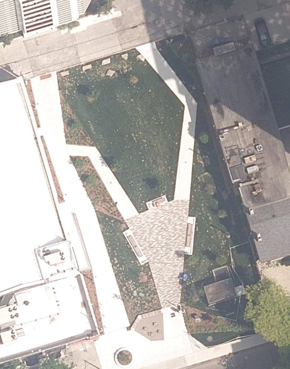
Aerial, City of Toronto orthophoto, ~8 cm/px source · cached 5/9/2026
Alexander Street Parkette scores 47 / 100. Strongest dimensions: enclosure / eyes on park and connectivity. Weakest: amenity diversity (0). Border-vacuum risk is low. This score is a transparent reading of Jane Jacobs-style vitality factors, not a definitive judgment.
Area · 0.11 ha
Weighted across six dimensions · confidence 54%
Scores are not bell-curved. Percentiles and expected scores provide context without changing the underlying model.
Loading map…
The parks map is loading.Explain this score
Where did the 47 come from? Each weighted contribution against a neutral 50 baseline. Green = pushed up; red = pulled down.
Sum of contributions = the headline score. A negative bar means that dimension dragged the park below the city-wide neutral baseline.
Why this park works
Alexander Street Parkette works because its edge activation score (45) is in the top tier and its connectivity (65) is also top quartile.
What limits this park
.
Most distinctive characteristic
Most distinctive feature: exceptionally high edge activation (45, top decile).
Jacobs reading
Alexander Street Parkette sits between an urban social park and an ecological retreat: moderately useful for both, exceptionally suited to neither.
Performance in context
- A modest overperformer for its urban plaza typology (+11 vs the median in pocket Urban Plaza).
Typology classification
Classified as Urban Plaza: 1095 m², paved (0% canopy), 45.0 buildings/100 m
Edge Activation
Within 100 m of the park edge: 33 active uses (transit_stop, retail, restaurant, cafe) and 5 dead/hostile uses (parking_lot, highway). Active edges keep "eyes on the park" through the day; parking lots, blank institutional walls, rail and highway frontages drain street life.
Source: OSM POIs (amenity/shop) + Toronto Building Footprints + land use
Connectivity
Connectivity blends paths, intersections, transit, entrances, and edge density. This park has 3 mapped paths/walkways and 5 sidewalk segments within 50 m; 10 street intersections within 100 m; 39 transit stops within a 400 m walk; 3 estimated access points across ~136 m of perimeter. edge density is healthy, no superblock penalty. Source coverage: centreline, pedestrian_network, transit_osm.
Source: Toronto Centreline V2 + Pedestrian Network + OSM transit stops
Amenity Diversity
No amenities recorded. Score is 0 until inventory is loaded.
Source: Toronto Parks & Recreation Facilities + OSM amenity tags
Natural Comfort
Natural Comfort requires inputs not yet loaded for this park (Treed Area / Ravine / Waterbodies / Street Trees). Score is held at a neutral 50 with low confidence. Read with caution.
Source: Treed Area / Ravine / Waterbodies / Street Trees
Enclosure / Eyes on Park
61 buildings within 25 m of the park edge (23 mid-rise, 15 low-rise, 23 tower); avg edge height 33.1 m (~11 floors); 45.0 buildings per 100 m of 136 m perimeter (strong frontage density); edges lean tall but still framed; 23 towers ≥ 40 m within 25 m of the edge. "Eyes on the park" come strongest from the 23 mid-rise edge buildings.
Source: Toronto 3D Massing (building footprints + heights)
Border Vacuum Risk
Border-vacuum factors within 50 m of the park: parking_lot, parking_lot. Jacobs warned that highways, rail, parking lots and blank institutional edges act as "vacuums" that suppress foot traffic and isolate the park from its neighbourhood.
Source: Toronto Street Centreline (highways) + rail layer + OSM landuse + building footprints
Equity Context
Equity Context requires inputs not yet loaded for this park (Toronto Neighbourhood Profiles). Score is held at a neutral 50 with low confidence. Read with caution.
Source: Toronto Neighbourhood Profiles
Amenities (0)
No amenities recorded for this park.
Nearby active-edge features (80)
- retail: Barbershop30 m
- parking lot43 m
- parking lot45 m
- cafe: Heytea53 m
- restaurant: Japadog54 m
- restaurant: Me-Va-Me55 m
- retail: INS Market56 m
- retail: Clutch Vape56 m
- restaurant: Firehouse Subs59 m
- parking lot66 m
- restaurant: HI Bowl66 m
- restaurant: Seoul Gamjatang66 m
- retail: Ho's Place67 m
- transit stop: Alexander Street71 m
- highway: Yonge Street74 m
- retail: Toronto Tees78 m
- transit stop: Grosvenor Street81 m
- retail: BZB Convenicne83 m
- parking lot83 m
- retail: Love Shop85 m
- retail86 m
- retail: Milano Nails & Spa86 m
- restaurant: Darvish Persian Cuisine87 m
- retail87 m
- restaurant: Mars Village Eatery88 m
- restaurant: Diyijia88 m
- retail: Thai Mart88 m
- restaurant: Hi Hoi Tod88 m
- cafe: Kati89 m
- restaurant: Taning Lemon Tea89 m
- retail: Effi Bike92 m
- restaurant: The Gluay94 m
- retail: Toronto Tees95 m
- restaurant: Bone Soup Malatang96 m
- retail98 m
- retail: Kream99 m
- retail100 m
- retail: Cash 4 You100 m
- restaurant: 555 Boat Noodles100 m
- parking lot102 m
- restaurant102 m
- restaurant: Church's Chicken104 m
- restaurant: The Fry105 m
- restaurant: Egg Club106 m
- restaurant: Domino's109 m
- retail: PP Pet110 m
- restaurant: Souper Hot Pot & Tea112 m
- parking lot113 m
- cafe: Daon Cafe114 m
- parking lot115 m
- parking lot116 m
- restaurant: Four Four South Village116 m
- parking lot118 m
- restaurant: Flaming Kitchen120 m
- restaurant: BOKU (Yonge St.)121 m
- retail122 m
- restaurant: McDonald's124 m
- parking lot124 m
- retail128 m
- retail: Adult Mart131 m
- parking lot135 m
- parking lot137 m
- retail: LCBO137 m
- restaurant: Taqueria El Pastorictio138 m
- retail: La Para139 m
- cafe: Charles Tea142 m
- highway: Yonge Street142 m
- restaurant: The Spice Village144 m
- restaurant: Pizza Pizza145 m
- parking lot146 m
- retail: Dollarama146 m
- restaurant: Mr Tonkasu146 m
- restaurant: Woojoo Bunsik151 m
- retail: Chakra Healing Zone152 m
- cafe: Tim Hortons153 m
- retail: E-Blue Esport Stadium156 m
- restaurant: McDonald's157 m
- transit stop: Carlton Street157 m
- restaurant: Fox and Fiddle161 m
- highway: Yonge Street163 m
Park profile
Five-axis radar across the structural dimensions.
Citywide percentile ranks
Across all Toronto parks in the dataset.
- Overall vitality92th
- Edge activation94th
- Connectivity82th
- Amenity diversity36th
- Natural comfort60th
- Enclosure81th
Most similar parks
Closest in metric space across the five structural dimensions.
- WATERFRONT NEIGHBOURHOOD CENTRE - Building GroundsWaterfront Park49
- Casimir Traffic IslandUrban Plaza46
- Kiwanis ParketteRavine / Naturalized Park49
- Toronto Hydro Green SpaceUrban Plaza49
- Parliament Square ParkCivic Square52
Most opposite parks
Furthest in metric space. Useful for recognising what kind of park this isn’t.
- Toronto Islands - Muggs Island ParkRavine / Naturalized Park25
- Trca Lands ( 26)Ravine / Naturalized Park27
- Rouge ParkWaterfront Park25
- Rouge ParkRavine / Naturalized Park21
- Rouge ParkRavine / Naturalized Park28
Human activity signals: not available
No activity signals have landed for this park yet. The model has scored its physical form but it can’t yet say how often it’s programmed, photographed, or walked through. See /data-ethics for what we will and will not collect.
Does this score feel accurate?
Your read of Alexander Street Parkettematters. We’re testing whether the model lines up with how people actually use the park. Submissions are stored locally; no account needed.
Tell us how this park feels
We measure structure (canopy, edges, connectivity). You measure feeling. Both matter, and disagreement is itself useful civic data.
What would improve this park?
Generated from the weakest measured dimensions: a starting point, not a prescription.
- Activate the edges: encourage cafés, retail or community uses on the streets that face the park; replace blank or parking-lot edges where possible.
- Diversify what people can do in the park (playground, washroom, water, shade, performance, sport, garden): even small additions raise this score.
Data sources
- City of Toronto Open Data: Parks (Green Space)Polygon boundaries, official names, types.
- Parks & Recreation FacilitiesInventory of in-park amenities (washrooms, fields, rinks…).
- Toronto Pedestrian NetworkSidewalk segments around and through parks; estimated park entrances.
- Toronto Centreline V2Street segments + intersection nodes near park edges; trails and walkways.
- Toronto 3D MassingBuilding footprints + heights for edge-building counts, frontage density, and tower-in-the-park risk.
- Toronto Treed AreaTree canopy share inside park polygons via stratified-grid sampling.
- Toronto Waterbodies & RiversWater surface inside parks + nearest-water distance for cooling.
- Ravine & Natural Feature ProtectionRavine overlap as a cooling / natural-comfort signal.
- Toronto Street Tree InventoryTree count + density inside park polygons.
- Neighbourhood Profiles(Pending) Equity context proxy.
- OpenStreetMap (Overpass API)Cafés, restaurants, retail, transit stops, parking, highways, rail.